
 |
| United We Stand |
|
|
|
|
|
Brainerd Area Amateur Radio Club |
|
Club Meeting March 25, 2004 |
|
|
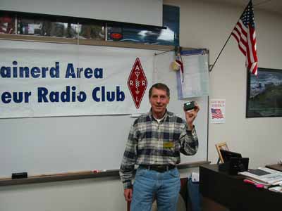
The BAARC will held a regular membership meeting Thursday, March 25th. Twenty-four hams showed up even though there was extremely dense fog making driving difficult. A presentation on APRS (Automatic Position Reporting System) was given by Lyle Kohler KØLR. Lyle has spoken to the club and other ham organizations before. He is a good speaker and the topic was very interesting.
|
| APRS
was developed by Bob Bruninga, WB4APR, who first introduced the APRS
concept to the ham radio community in 1992. APRS is used to transmit
digitized information such as position reports, weather data and messages
between users. Technologies involved include packet radio, the Global
Positioning System (GPS), and the Internet. Among
the many uses for APRS are emergencies and public service events, weather
station reporting, Skywarn, radio direction finding, keeping track of
traveling friends, and just plain fun. APRS station types include fixed
weather stations, mobile trackers, digipeaters, and Internet gateways. A
mobile tracker station requires a GPS receiver with a serial data output,
a packet terminal node controller (TNC), a 2 meter radio and an antenna.
The TNC does not need to be a full-featured controller -- it doesn't even
have to be able to receive. Low-cost TNCs designed specifically for this
application include the Byonics
TinyTrak3 ($36 kit, $60 wired), and the Tigertronics TigerTrak TM-1
($89.95). Byonics has just announced a "PocketTracker",
combining a TNC and a 2m QRP transmitter on a circuit board that fits into
an Altoids tin. The price (not including Altoids tin and mints) is $89.
Somewhat higher on the price scale, Kenwood offers the TH-D7AG dual-band
HT with built-in TNC for about $325, and the TM-D700A dual-band mobile
with internal TNC for about $465. Mobile
trackers can operate in several modes, including a timed beacon mode or a
"smart" beacon mode, in which a transmission is made whenever
there is a significant change in speed or direction. There is also a
"MIC-E" mode that adds a compressed data burst at the end of a
voice transmission. As with other packet TNCs, mode information, station
call sign, beacon message, etc. are programmed by the user via a
computer's serial port. An
APRS base station requires a computer, a TNC (more about this later) and a
2 meter receiver. It takes only a few minutes to set up a field-portable
APRS base station for emergencies or community service events. APRS
software is available for all popular operating systems including DOS,
Windows, Mac, Linux and Palm. Actually a TNC is optional. A packet engine
program called "AWGPE", developed by George Rossopoulos,
SV2AGW, uses the computer's sound card to perform the TNC functions, and
will work just as well as a "hardware" TNC. For Windows, the
most popular APRS programs include WinAPRS, UI-View, APRS + SA (Street
Atlas), and a new one from SV2AGW called AGWTracker. I have been using
UI-View, which is available in a freeware version or in a registered
version for about $19 US. Some computer mapping programs are directly
supported by your APRS software so that station positions will be
automatically displayed on a detailed map. However, you can also load your
own maps from other sources and create custom maps, if you are able to
specify the exact geographic coordinates of two points on the map. In the US, the "official" packet
frequency is 144.390 MHz. There is also some APRS activity using 300 baud
packet on HF, primarily on 30 meters. By tuning your HF receiver to 10,151
kHz in LSB mode (10,151.51 kHz for some TNCs including the AWG sound card
packet engine), you may be able to copy APRS stations from all over the
country. If you have Internet access, you don't need a receiver at all. There are several ways of accessing the www.findu.com database via your Web browser, allowing you to locate a specific station or to keep track of all APRS stations in a given region of the world. Using WinAPRS or UI-View, you can also connect to an APRS server directly, so that you can view "real-time" activity and even exchange text messages with other connected stations. At present there is not much APRS activity
in this part of Minnesota, and to my knowledge there are no digipeaters
that will pick up a mobile
tracker reliably in the Brainerd area. That should change in the near
future, as Terry, WØTVD and John, AF9T are planning to install a 144.39
digipeater at the Aitkin DX Cluster site northeast of Crosby. This will
provide coverage for portions of Crow Wing and Aitkin Counties. Packet radio is not very tolerant of noise
or dropouts on the channel, and normally relies on multiple transmissions
until an "ack" is returned from the receiving station. However,
APRS transmissions are one-way -- the sending station simply hopes that
all receiving stations get the message. Because of that, the range between
a mobile tracker and a digipeater will be considerably less than the range
of a voice repeater with the same antenna and power level. Fortunately, if
one position report is missed, it is usually not critical to the
"mission". And as with other amateur packet applications, any
station with a full-featured TNC can become a digipeater to provide more
complete coverage or to replace a digipeater that is out of service. Packet radio requires that you specify the
path that you want your transmissions to follow. With APRS, it's easy
because the network uses identically
named digipeaters. Every digi is a "Relay", and "Wide"
is used for digipeaters higher than 100 feet. So if you set up your TNC
with the path "Relay, Wide, Wide" it will get you through the
first three hops. There are other more advanced methods of specifying the
path, and you should use the minimum number of hops to keep from flooding
the network with packets. Detailed information on digipeater operation and
TNC setup can be found on the Internet. In summary, APRS brings position tracking
capability within the reach of every ham, and can provide a powerful tool
for public service and emergency communications. If you already have a
radio and a GPS, APRS tracking capability can be added for as little as
fifty dollars. A wealth of information on APRS is available on-line. Here
are a few links to get you started: http://web.usna.navy.mil/~bruninga/aprs.html Bob Bruninga's page http://www.findu.com
APRS database http://www.wulfden.org/APRSQuery.shtml Search for APRS stations http://www.byonics.com/ Byonics web site http://www.gpstracker.com/ Tigertronics tracker products http://www.winaprs.org
WinAPRS software http://www.ui-view.com
UI-View software http://www.qsl.net/soundcardpacket
How to use the sound card packet engine http://www.raag.org/sv2agw/ AGW Packet Engine and AGWTracker http://nwaprs.org/digipeating.htm
Notes on APRS Digipeaters 73 Lyle, KØLR |
 |
The next BAARC Membership Meeting will feature a presentation about lightning protection by Roger Williams WØWUG. Everyone is welcome and encouraged to attend. |
This page was last updated 12/19/2006 Ø